Telling Stories with Esri Story Map
This month at Maptime Madison, Clare Trainor will discuss the importance of storytelling and show you how to create and use Esri Story Maps. What are Story Maps? They are web applications that let authors combine beautiful maps with narrative text, striking images, and multimedia, including video. The applications are designed to be attractive and usable by anyone. We will walk through a variety of examples and show you how to use Esri Story Maps to help transform your data and idea into a powerful story.

Supplies
There will be several laptops available for your use provided by the Madison Public Library! Feel free to bring your own laptop too. If you can, please make a free account at Esri and bring an idea of a story you would like to tell!
Pizza!!!
There will be free pizza donated by Carto! Please RSVP so we know how much pizza to get!
When and Where
Monday, January 30th, 6pm - 8pm @ Madison Public Library: Central Library @ the Bubbler 201 W Mifflin St Madison, WI 53703
Thematic Mapping with Carto!
Event Recap: Carto For the December 2016 edition of Maptime Madison we learned about thematic maps and Carto from Kristen Vincent, a Maptime Madison co-organizer. It was a great time learning about web mapping with Carto!
Thanks again to Carto for the free pizza!
If you missed out on joining us at the Bubbler for thematic mapping with Carto, you can view Kristen’s slides here.
Next Maptime! Thank you to everyone who came out for this event! Join our mailing list or follow us on Twitter @Maptime Madison for the announcement of our January/February 2017 event! Hope to see you soon!
Thematic Mapping with Carto Builder!
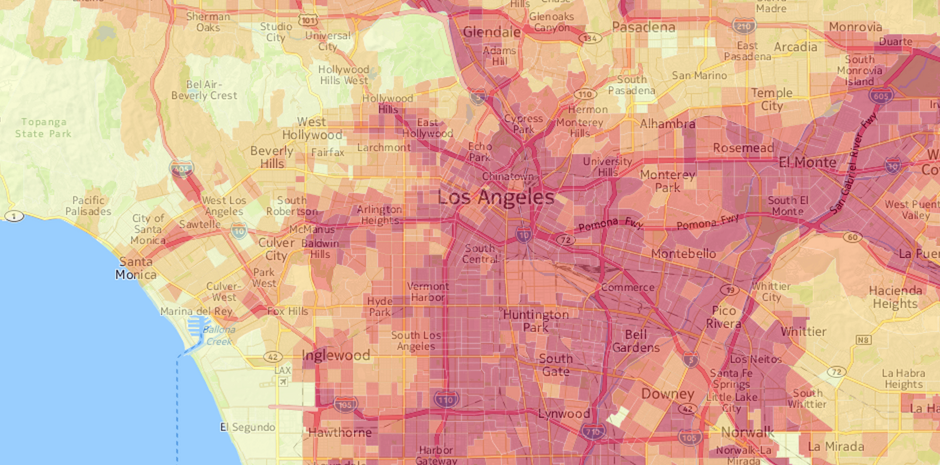
This month at Maptime Madison, Kristen Vincent will show us how to make an interactive thematic map with Carto, formerly CartoDB! But first, what in the world is a thematic map? Thematic maps use number based data to show the distribution or pattern of a particular geography. We’ll review a few thematic map types (examples here, here, and here), discuss best practices, and talk data before turning to Carto Builder—a web-based mapping and spatial analysis tool—to make interactive choropleth maps of US population data. With these new tools under your belt, you’ll be able to explore and display any spatial dataset thematically!
Supplies
There will be several laptops available for your use provided by the Madison Public Library! Feel free to bring your own laptop too. If you can, please make a free account with Carto before Maptime begins!
Pizza!!!
There will be free pizza donated by Carto! Please RSVP so we know how much pizza to get!
When and Where
Wednesday, December 7th, 6pm - 8pm @ Madison Public Library: Central Library @ the Bubbler 201 W Mifflin St Madison, WI 53703
Sculptural Maps
It’s time for a new season on Maptime Madison!
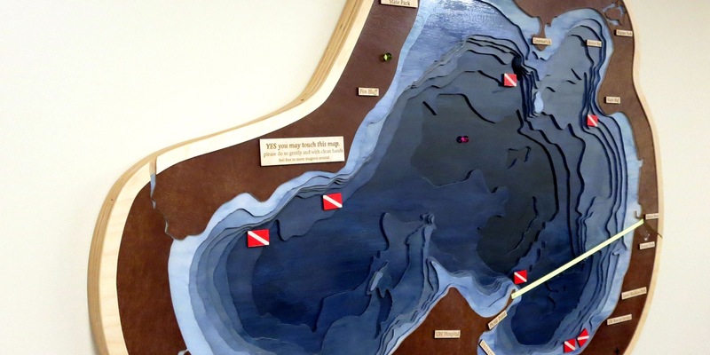
To kick things off, we’ll have a “show and tell” as cartographer Caroline Rose will talk about sculptural or three-dimensional maps, including lessons learned in creating them and examples from many different cartographers. Caroline has been creating and admiring sculptural maps for many years, and she helped curate a tangible maps exhibit in Minneapolis in October of 2015. The presentation will take place in the Chart Room North, Memorial Union on the UW-Madison campus, where her 3D, magnetic map of Lake Mendota is installed.
Supplies
Feel free to bring your own examples of sculptural maps to share after the presentation!
Pizza!!!
Unfortunately, no outside food can be brought into the meeting space, so after the presentation, we will move outside to the Terrace to enjoy free pizza provided by Carto. Please RSVP so we know how much pizza to get.
When and Where
Wednesday, October 5th, 6pm - 8pm @ Chart Room North, UW-Madison Memorial Union, 800 Langdon Street, Madison, WI 53706
NOTE: NEW LOCATION FOR THIS MAPTIME ONLY
Missing Maps Mapathon
This month at Maptime Madison, we’ll be working with the rest of the US Maptime community to help Missing Maps, a group of nonprofits dedicated to mapping the world’s most vulnerable populations. We’ll give a brief introduction of what Missing Maps and Open Street Map are, how to edit and trace satellite imagery in Open Street Map, and start mapping! If you’re unfamiliar with OSM, feel free to go through some of the Missing Maps’ tutorials, but we’ll spend some time going through the basics.
![]()
Supplies
If you have a laptop, please feel free to bring it. We will also have about 10 laptops available for people to use.
Pizza!!!
There will also be free pizza provided by Missing Maps. Please RSVP so we know how much pizza to get.
When and Where
Thursday, May 12th, 6pm - 8pm @ Madison Public Library: Central Library @ the Bubbler 201 W Mifflin St Madison, WI 53703