Photo Mapping part II!
Mapillary is a platform for crowd-sourcing street-level imagery. Anyone can create high quality geo-referenced imagery by installing the app and taking a walk with a GPS enabled camera or smart phone. Based on all of these images, Mapillary is able to determine the location of all sorts of fixed objects such as traffic signs. Pretty cool stuff. Check it out at www.mapillary.com
Instructions for All
- Create an account on www.mapillary.com
- Download the Mapillary App to your smart phone.
- Go Map! (Or follow next instructions to use LG 360 Cam).
Instructions for Setting up the LG 360 Cameras
- Download the LG 360 Cam App, the LG 360 Camera Manager to your smart phone. The one with this icon:

(The first time you launch the app, you may have to click through some dialog boxes and agree to the terms of use). If it asks you to allow location access, easiest to just click Allow.
-
Turn on Bluethooth
-
Ensure that the cam is ON. Power button the side; blinking red light indicates ON.
-
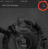
Click the Device Search button in the LG 360 App
-
The app will show the cameras it finds nearby. The last three digits of the ID are the numbers written on the camera bodies (503, 870, etc). Click on your camera. You will then be prompted to connect to the camera’s wifi.
-
Go to your phone’s wifi settings and connect to the network:
- name:
LGR***_***XXX.OSC - password:
mapillary
Where XXX are the last three digits of your device’s ID, as indicated on the camera body.
- name:
-
Open the Mapillary App and login.
-
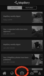
Go to Camera Mode:
-
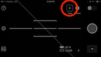
Click the +CAM button:
-
Click
Search -
Click
Add Camerawhen it finds your camera.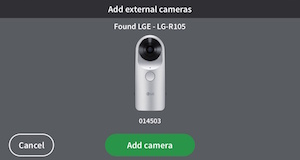
-
It will take a moment to load and then a test photo will appear to show that it is connected.
Start A New Photo Sequence
- Press the Big Red Circle Record Button to start a new sequence. The camera will automatically capture images as you move. If you stop moving, the camera will pause.
The camera will make a “shutter noise” and the image count in the bottom right corner will increment as you move to let you know it is capturing new images. If this number is not incrementing, you may need to restart the app and reconnect to the camera.
Uploading to Mapillary
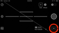
- Click the transfer arrow to download the photos from the camera to your phone.
-
This will transfer images from the camera to your Mapillary app (note, they are not uploaded to Mapillary yet).
-
Preview the photos, and when you are satisified, click upload.
Troubleshooting
- The wifi will only stay enabled for a short amount of time, if you cannot find your camera’s wifi network, go back to step 3.
- There are a lot of wireless signals in the air. You may have to try this process many times before it finally sticks.
- the device WIFI password is
mapillary, all lowercase, note the twol’s