Show and Tell and Learn
Join us this month at Maptime Madison for Show and Tell and Learn! We’ll open the floor for you to share a map that you’ve made, a project in progress, or something mappy that you love to look at! The goal is to show off all of the amazing work the Madison mapping community is a part of! You don’t have to be a map expert either. The idea is to provide a supportive learning environment to learn about process, workflows, technologies (old and new) and new ideas. No need to prepare anything ahead of time! Everyone can have 5-10 minutes to share, discuss, ask questions, and get constructive feedback. Just bring something map related (print or digital format work great) and questions!
Supplies
Please bring a map to share! If you have a laptop, feel free to bring it along. There will computers available as well provided by Central Library.
Snacks
There will be snacks to share!
When and Where
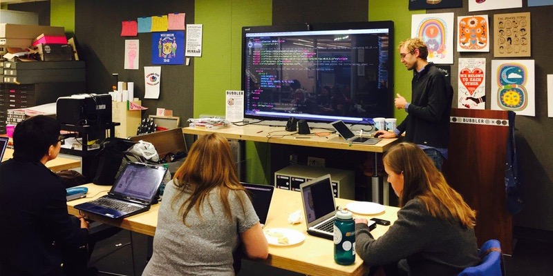
Monday, April 24th, 6pm - 8pm @ Madison Public Library: Central Library @ the Bubbler 201 W Mifflin St Madison, WI 53703
Web Mapping with D3.js
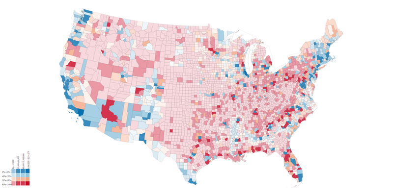
This month at Maptime Madison, Eric Nost will take us one step further in the world of web mapping! Tools like CARTO make it relatively simple to produce interactive web maps, but sometimes you want to have greater control of the design, especially when your map is part of a page or website. For that, it’s often handy to turn to programming. We’ll walkthrough the basics of programming, what programming means in web mapping, and how to get started. In our tutorial we’ll use D3.js—a Javascript library for dynamically generating SVG graphics—to make a map of the 2016 presidential election.
Supplies
Please bring a laptop if you have one, otherwise, there will be computers available for your use.
If you want to get started early, you can download the files that we’ll work with here!
If you plan on using a Windows system, you’ll need to download and install Prepros in order to render your map (Mac is way easier!). For either Windows or Mac, you’ll also need a text editor to view and change the code. You can use the defaults on either system, but you might find it much easier to use a text editor specifically designed for programming, such as Sublime Text.
If you don’t have time to download these before Maptime, don’t worry! We’ll walk through the downloads right away.
When and Where
Monday, March 27th, 6pm - 8pm @ Madison Public Library: Central Library @ the Bubbler 201 W Mifflin St Madison, WI 53703
OpenStreetMap (OSM) Data Editing
Event Recap: OpenStreetMap (OSM) Data Editing For the February 2017 edition of Maptime Madison, we learned about OpenStreetMap (OSM) from Spencer Gardner, a transportation planner here in Madison. Thank you, Spencer, for teaching us all about OSM!
If you missed out on joining us at the Bubbler last month or want to look back at what we learned, you can check out Spencer’s slides here.
Here are some additional resources for OSM downloads:
And some OSM tutorials and references:
- http://learnosm.org/en/
- https://wiki.openstreetmap.org/wiki/Main_Page
- https://taginfo.openstreetmap.org/
Next Maptime! Thank you to everyone who came out for this event! Join our mailing list or follow us on Twitter @Maptime Madison for the announcement of our next 2017 event! Hope to see you soon!
CARTO Builder Workshop
Join us for a special CARTO Maptime on Monday, March 6, 2017 at the University of Wisconsin-Madison Cartography Lab! CARTO Senior Cartographer, Mamata Akella, will lead a workshop reviewing the basics of CARTO Builder before turning to advanced analysis and thematic mapping. Mamata will cover GIS workflows, TurboCARTO, CARTOColors, Widgets, Auto-Style, and everything in between!

Supplies
Please bring a laptop if you have one, otherwise, there will be computers available for your use.
When and Where
Monday, March 6th, 6pm - 8pm @ Science Hall, Cartography Lab Room M390, on the University of Wisconsin-Madison campus: 550 North Park Street, Madison, WI. To get to the lab, take the elevator or stairs to the 3rd floor of Science Hall. Take a right and walk to the end of the hallway. Take the stairs on the left to reach the cartography lab.
OpenStreetMap (OSM) Data Editing
This month at Maptime Madison, Spencer Gardner, a Maptime regular and transportation planner here in Madison, will teach us about OpenStreetMap (OSM). We will have a general overview of OSM, its origins and growth as a data platform, and current applications. We will also discuss the data model and learn about platforms for editing OSM data in our own neighborhoods. Finally, we will leave some time for people to try their hand at edits!

Supplies
There will be several laptops available for your use provided by the Madison Public Library! Feel free to bring your own laptop too. If you can, please make a free account at OSM. Click here to learn about JOSM, which will be brought up a little in the presentation (note–requires Java, but not necessary for editing OSM). Here is additional information to learn about OSM!
When and Where
Monday, February 27th, 6pm - 8pm @ Madison Public Library: Central Library @ the Bubbler 201 W Mifflin St Madison, WI 53703